

Three layers of intelligence. One complete picture.
Avant connects world-leading InSAR data into simple, easy-to-understand data reports. It integrates with our monitoring user platform, and connects with other datasets and live IoT sensors - bringing every layer of land-stability intelligence into one place.
Avant's InSAR technology is supplied and supported by:
Who supplies the data

SatSense
Supplies Avant with InSAR ground-movement data across New Zealand. Founded in 2018 at the University of Leeds by Professors Tim Wright and Andy Hooper. Specialists in InSAR land-stability measurement, accurate to within a few millimetres per year.

Earth Sciences New Zealand
Formerly GNS Science. SatSense works in partnership with Earth Sciences New Zealand, the country's primary earth-science research institution, which delivers nationwide Sentinel-1 InSAR coverage on a 12-day cycle.
How satellite radar becomes property intelligence.
Satellite Capture
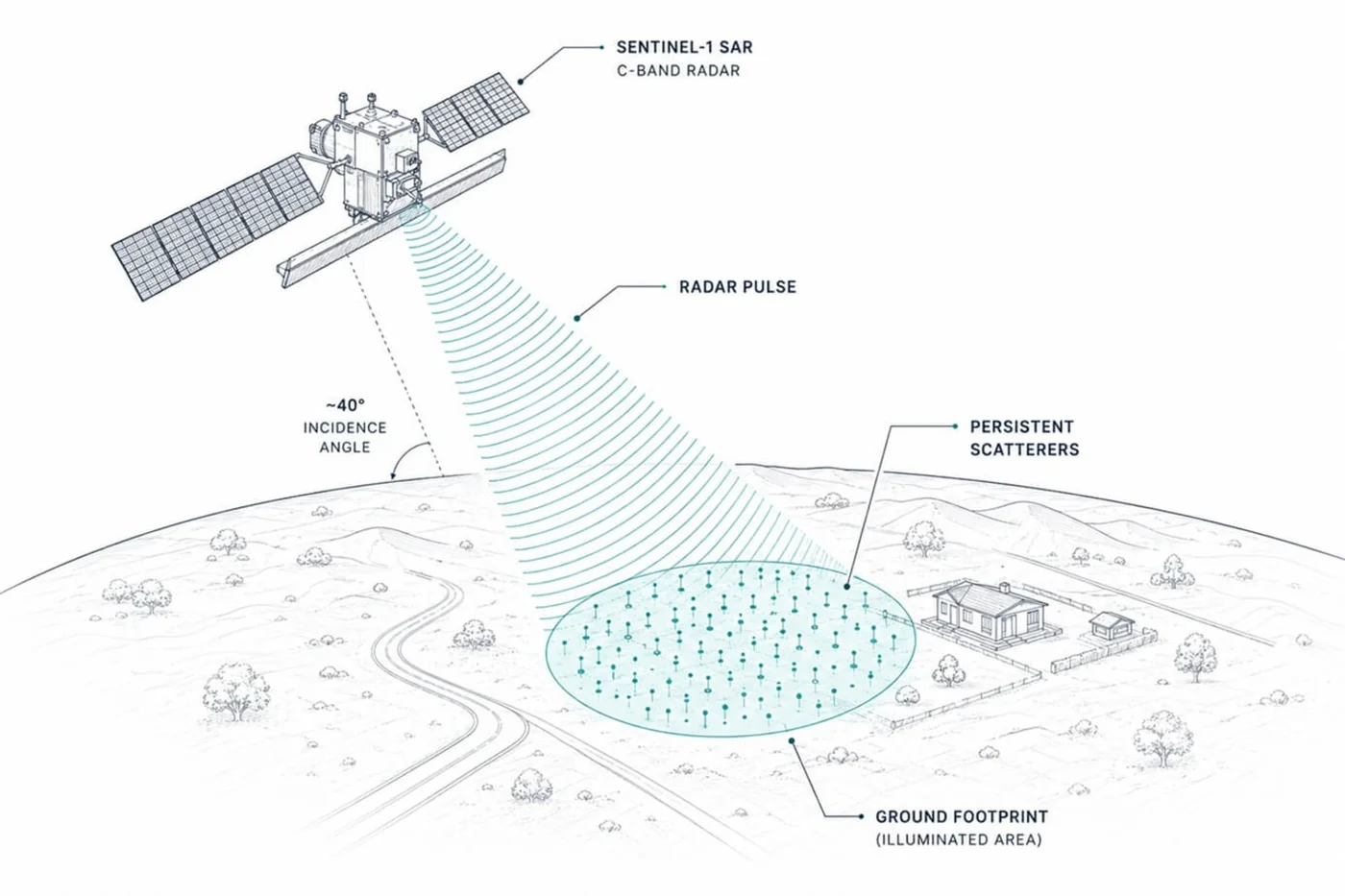
ESA Sentinel-1 C-band radar satellites scan the same points on earth’s surface every 12 days, detecting even the smallest phase shifts in the returning radar signal - day or night, through cloud cover.
SatSense Processing
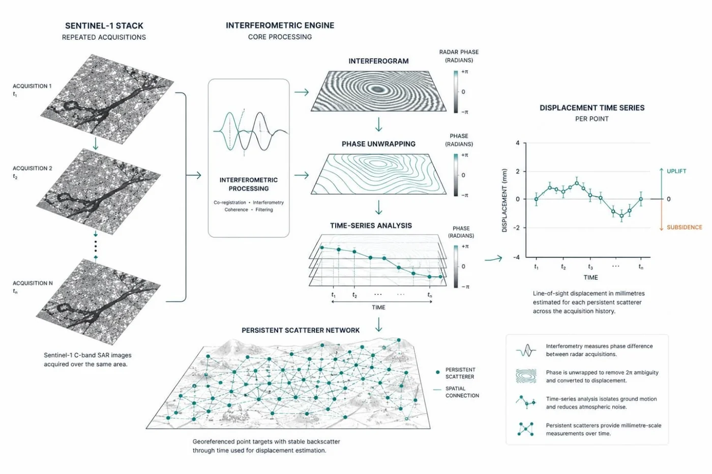
SatSense’s algorithms compare radar images over time, extracting displacement data with ±2-5mm/yr precision from hundreds of millions of ground points across New Zealand.
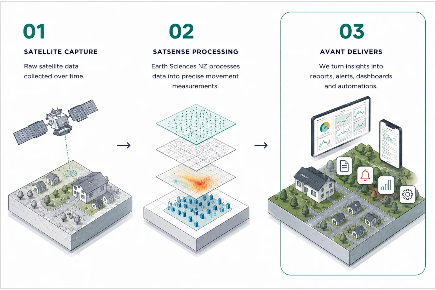
AVANT Delivers
AVANT combines SatSense’s data with NZ geology, soil maps, flood records and hazard layers - generating your LandSure property report and digital twin, which show where measured ground movement has been recorded.
The New Zealand AI company behind LandSure.
AVANT Global was established in early 2023 in Whangārei, Northland. We are a group of geospatial and computer scientists - from New Zealand and around the world - working in Geographic Information Systems (GIS), IoT sensors, satellite imagery and Digital Twin technology.
We don’t claim to have invented the science. Our job is to bring the world’s best satellite and earth-science data together, make it genuinely useful, and apply it responsibly to New Zealand’s land. We’re proud to have supported organisations who trust us with serious work.
A few of the organisations we’ve worked with


AVANT is located in Whangārei-te-rerenga-parāoa - the gathering place of whales. We stand as Tangata Te Tiriti, committed to the values of Kaitiakitanga - the guardianship of the natural world.
SatSense ground movement data. Now in New Zealand.
SatSense was founded in 2018 at the University of Leeds by Professors Tim Wright and Andy Hooper - two of the world’s leading geodesy scientists - building on decades of combined algorithm development.
Their aim was straightforward: take InSAR technology that was once only available to governments and space agencies, and make it accurate, affordable and accessible.
SatSense’s technology is now embedded in New Zealand’s national-scale land movement mapping. Working in partnership with Earth Sciences New Zealand (formerly GNS Science) - the Crown research institute responsible for geohazard science - they have built national ground motion datasets for New Zealand. This work supports Earth Sciences NZ’s public-good research into landslides, subsidence and other geohazards.
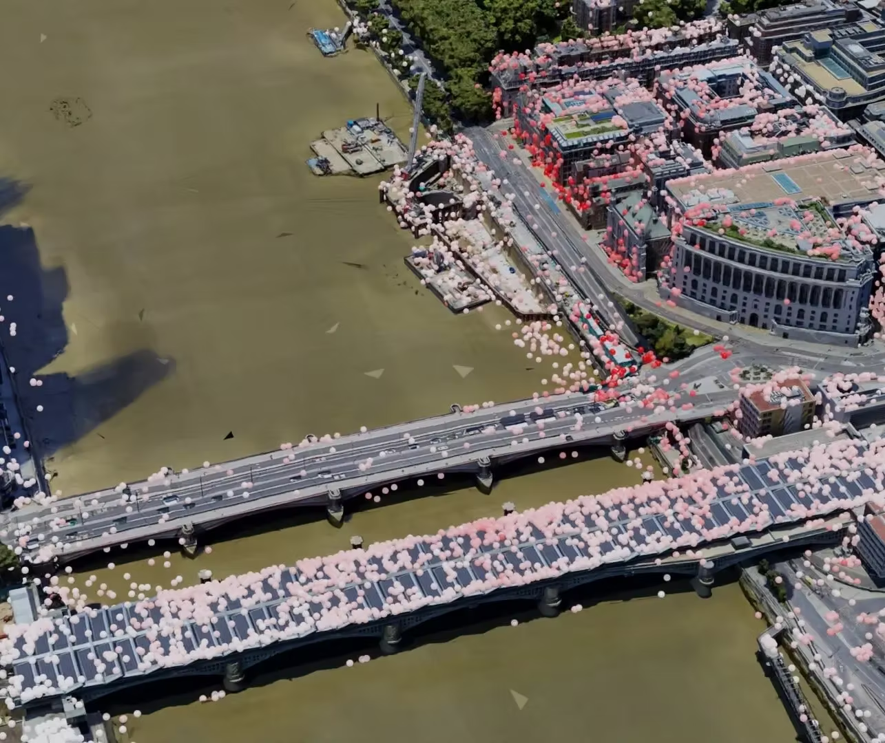
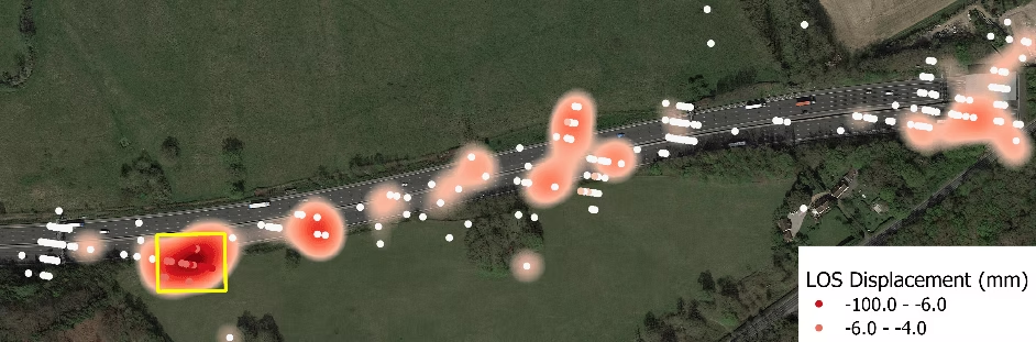
The monitoring starts with the European Space Agency’s Sentinel-1 C-band radar, which revisits the same ground about every 12 days over New Zealand and measures movement along its line of sight - toward or away from the satellite - to a few millimetres a year. Combining its two viewing directions separates up-and-down from east-west movement. Proprietary algorithms reduce noise and extract movement trends from up to ten years of archived satellite passes - detecting not just movement, but changes in its rate.
The team behind the technology
35 years of academic excellence. Built into every data point.
The SatSense team combines world-leading academic credentials with hard-won commercial experience across six continents. Their founders haven’t just studied ground movement - they have spent careers advancing the fundamental science that makes InSAR possible.

Leads SatSense product development - making complex ground movement data accessible and actionable for engineers, insurers and property professionals worldwide. Co-presented SatSense’s InSAR capabilities at the GRSG webinar 2025.

Professor of Satellite Geodesy at the University of Leeds. Director of COMET. Winner of the AGU Geodesy Section Award (2014) and the Royal Astronomical Society Harold Jeffreys Lectureship (2017). Co-founded SatSense in 2018.

Professor of Geodesy and Geophysics at the University of Leeds. Pioneer of the StaMPS algorithms now used globally across the InSAR community. His 35 combined years of algorithm development with Tim Wright form the scientific foundation of every data point.

Remote sensing specialist with 10+ years of InSAR processing experience at national scale. PhD in Geodesy and Geophysics (University of Leeds). MSc in Aerospace Engineering, Earth and Planetary Observation (Delft University of Technology).

The commercial force behind SatSense’s global expansion, on a mission to democratise ground movement data - making technology once reserved for space agencies available to businesses, engineers and property owners worldwide.

Leads SatSense’s New Zealand applications. Presented NZ geothermal InSAR case studies at GRSG 2024, showing how InSAR monitors reservoir management and pipeline infrastructure in Aotearoa’s geothermal fields.
In partnership with
Earth Sciences New Zealand.
Earth Sciences New Zealand (formerly GNS Science) is the country’s primary public institution for earth science research - responsible for understanding and reducing the impacts of natural hazards on New Zealand’s people, places and economy. Together with SatSense, it delivers nationwide Sentinel-1 InSAR coverage on a 12-day refresh cycle, supporting public good research across the motu.
Detecting magma movement and surface deformation in the Taupō Volcanic Zone.
Measuring vertical land movement along NZ’s dynamic coastline to understand how the land itself is rising or sinking relative to sea level.
Using Sentinel-1 InSAR to detect slow-moving slope failures across NZ’s high-risk regions - including urban areas affected by extreme weather events.
Mapping co-seismic and post-seismic ground deformation at national scale - revealing how the land responds before, during and after major seismic events.
Ready to understand your land?
Join the growing number of homeowners, engineers and organisations across New Zealand who are using LandSure to monitor, protect and make smarter decisions about the land beneath them.
Please read before you buy. A LandSure report is a satellite measurement. It is not an inspection, an engineering assessment or a warning system, and satellite radar does not measure all land equally well. Nine things to know before you buy.