Rural Land and Water Records

The public records on a rural block, in one report.

Land cover from 1996, ground shape and groundwater, surface water and water quality, climate, published pasture, forestry and crop maps, protected land, and earthquake and coast records. Every figure is printed with its source and record date.

$199incl. GST, for a block up to 50 ha. $249 and $299 for larger blocks.
Rural Land and Water Records sample cover for a sample block in Northland: an aerial photo of the 32.9 ha block, 31 datasets and the list of sectionsLand cover on record page from the sample reportSurface water and water quality page from the sample report
The sample report is 40 pagesThe number of pages depends on the records found and the crop pages ordered.
Source and date on every figureEach record is printed with its publisher and record date.
Emailed as a PDFWithin 24 hours of payment.
Priced by the block's legal areaThe area comes from the block's LINZ record.

What the report shows.

Each picture below is cut from the sample report for a sample block in Northland, with its address, legal description and title numbers withheld.

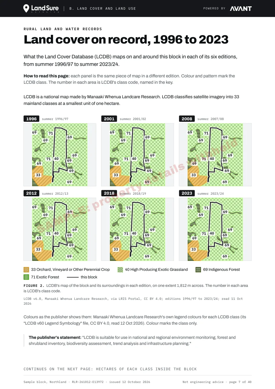
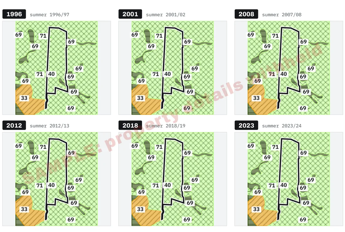
Land cover on record from the sample report: six panels of the same map, one for each Land Cover Database edition from 1996 to 2023, with the block outlined

Land cover on record, 1996 to 2023

What the Land Cover Database maps on and around the block in each of its six editions.
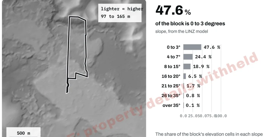
Ground shape from the sample report: a shaded map of the ground with the block outlined, beside the share of the block in each slope class

Ground shape and groundwater

The shape of the ground from the LINZ elevation model, and what a national groundwater model holds for the block.
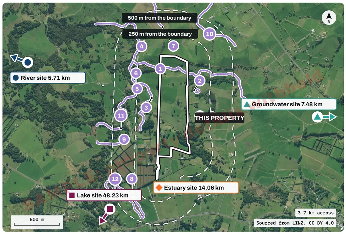
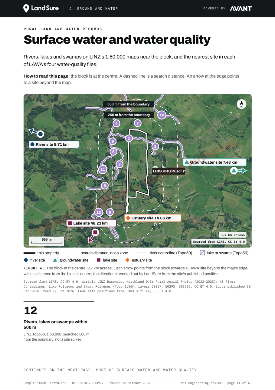
Surface water map from the sample report: numbered rivers and streams near the block, with arrows to the nearest river, lake, groundwater and estuary monitoring sites

Surface water and water quality

Rivers, lakes and swamps on LINZ's 1:50,000 maps near the block, and the nearest site in each of LAWA's water-quality files.
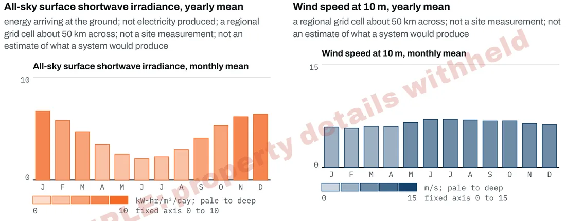
Climate charts from the sample report: monthly sunshine energy and monthly wind speed for the regional grid cell

Climate and energy records

NASA's published averages of sunshine energy, wind and temperature for the regional grid cell that contains the block, and the nearest national grid line, structure and site.
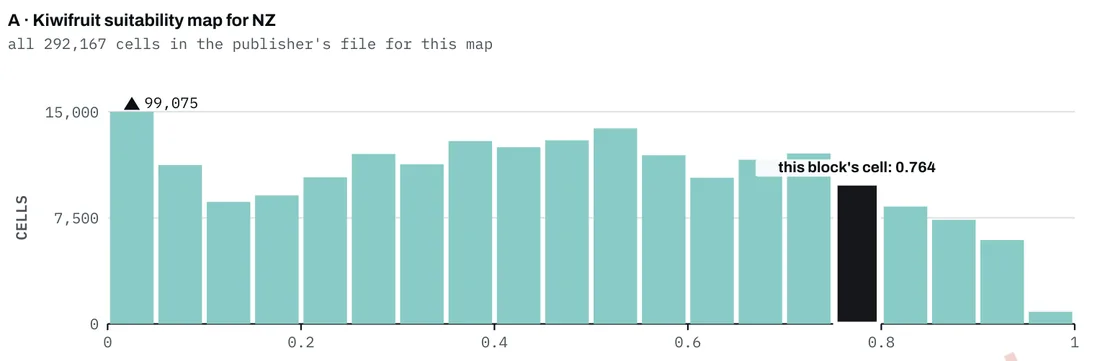
Kiwifruit crop page chart from the sample report: where the block's grid cell sits among every cell in the publisher's file

Crop maps as published

One section for each crop page ordered (kiwifruit, avocado, maize grain), with the publisher's legend, units, date and what it says the data is fit for.
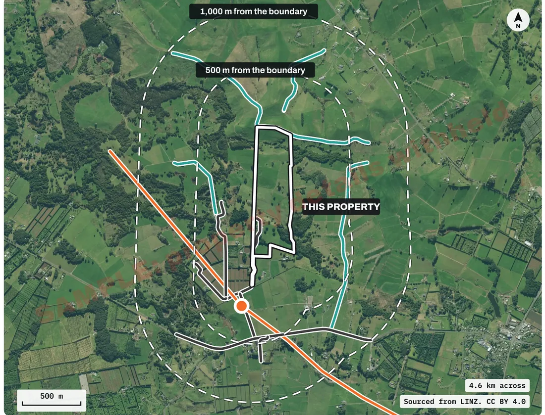
Protected land, access and corridors map from the sample report: roads, a transmission line and waterways near the block, inside 500 m and 1,000 m rings

Protected land, access and corridors

Conservation land, covenants, Crown land, protected areas, tracks, roads, rail and national grid lines on record near the block.

When it is useful.

1

Before you buy a block

See what public datasets record about the land, its water and what is mapped around it, in one PDF, before you commit.

2

While you run it

Keep a dated copy of the records on the block: land cover, mapped water, climate averages and the published farm and crop maps.

3

Before you list

Read the same public records a buyer or their adviser can look up, before the block goes on the market.

What is in the report

The sections of the report.

The sections below are from the sample report for a sample block in Northland, a public example with a kiwifruit crop page and with its address, legal description and title numbers withheld. The report covers only the datasets listed in its Appendix B, and names each dataset it left out, with the reason. The number of pages depends on the records found and the crop pages ordered.

Before you start

  • About this report and how to read it
  • The records at a glance: each section, how many datasets it holds and how many of them found a record

The block

  • This block and how it was read: the LINZ parcel, the parcels next to it and the title LINZ holds for it

Land cover and land use

  • Land cover on record, 1996 to 2023: what the Land Cover Database maps on and around the block in each of its six editions

Ground and water

  • Ground shape and groundwater: the shape of the ground from the LINZ elevation model, and what a national groundwater model holds for the block
  • Surface water and water quality: rivers, lakes and swamps on LINZ's 1:50,000 maps near the block, and the nearest site in each of LAWA's water-quality files

Climate and energy

  • Climate and energy resource records: NASA's published averages of sunshine energy, wind and temperature for the regional grid cell, and the nearest national grid line, structure and site

Published farm and crop maps

  • Pasture and forestry as published: modelled pasture growth under five published scenarios, and MPI's site classes for three forestry species
  • Crop maps as published: one section for each crop page ordered (kiwifruit, avocado, maize grain), with the publisher's legend, units, date and what it says the data is fit for

Around the block

  • Protected land, access and corridors: conservation land, covenants, Crown land, protected areas, tracks, roads, rail and national grid lines on record near the block

Earthquakes and the coast

  • Earthquake and coast records: earthquakes on GeoNet's catalogue within 150 km over ten years, the coastline on LINZ's 1:50,000 maps and the nearest NZ SeaRise coastal site

Reference

  • Appendix A: the record tables, one row for each figure, with its source, licence and the publisher's caveat
  • Appendix B: sources, attribution and methods, with each source's licence and period or vintage
  • Not included, and the record of this report: every dataset left out, with the reason

Sample pages

Pages from the sample Rural Land and Water Records report for a sample block in Northland, with its address, legal description and title numbers withheld (40 pages, with a kiwifruit crop page). Click a page to see it full size.

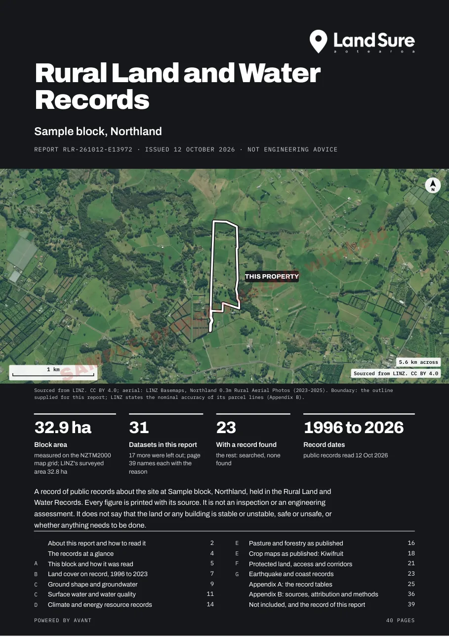
Rural Land and Water Records sample cover for a sample block in Northland: an aerial photo of the 32.9 ha block, 31 datasets and the list of sections

Cover - the block on LINZ aerial imagery, its area, the number of datasets and the contents.
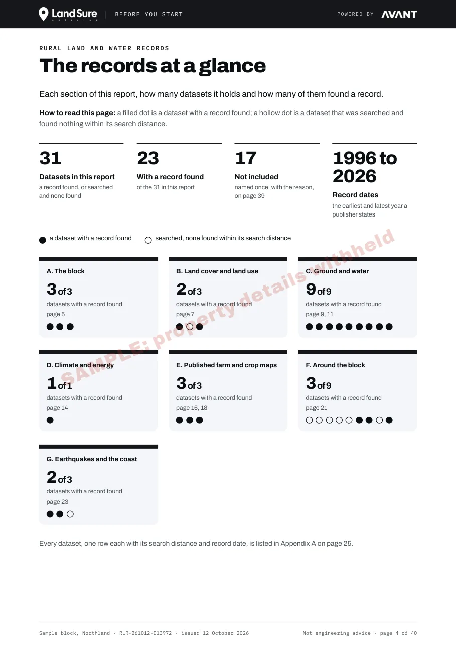
The records at a glance page: each section with how many datasets it holds and how many of them found a record

The records at a glance - each section, how many datasets it holds and how many found a record.
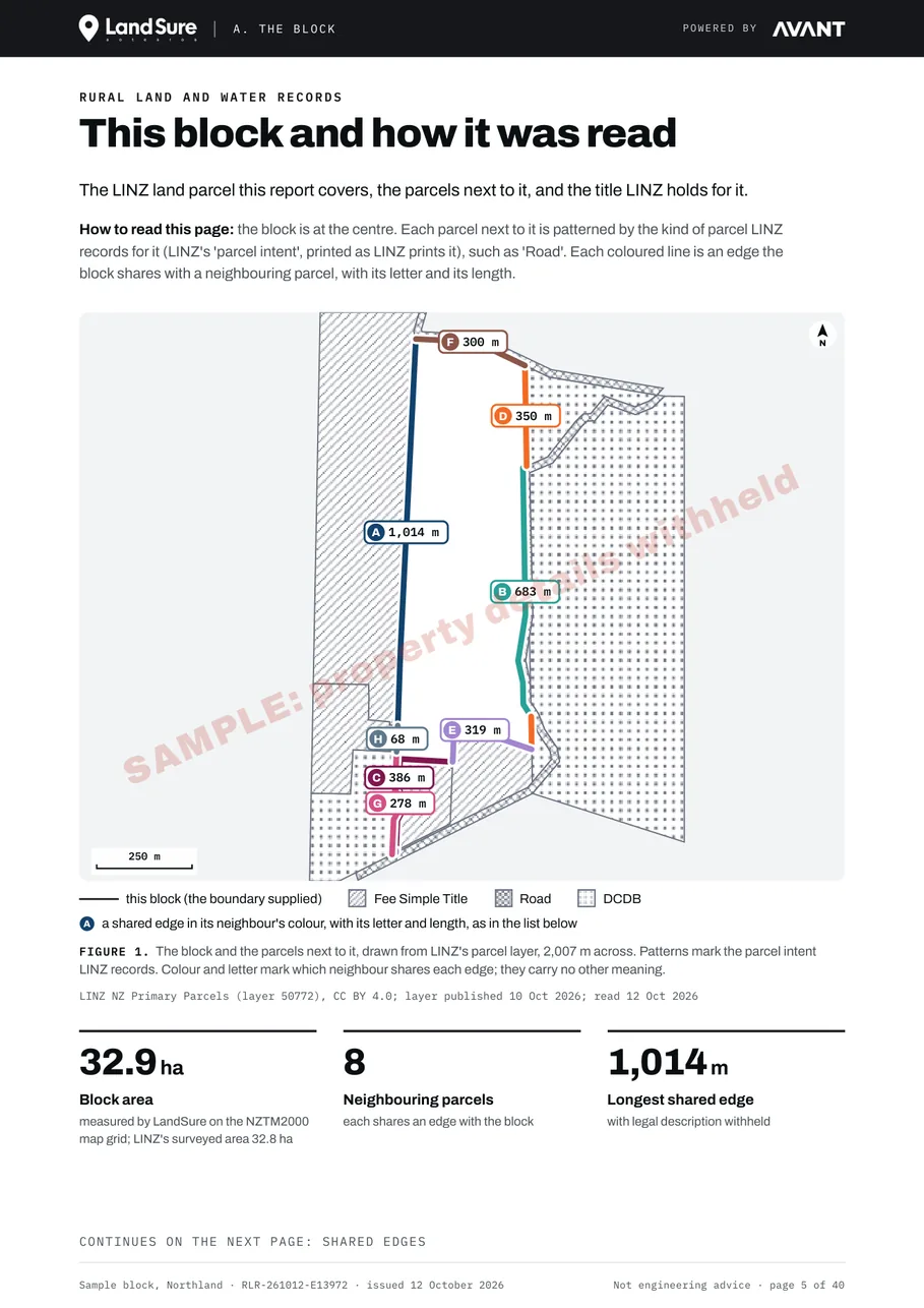
This block and how it was read page: the LINZ parcel on a map with the parcels next to it

This block and how it was read - the LINZ parcel and the parcels next to it.

Land cover on record page: six panels of the same map from the Land Cover Database editions from 1996 to 2023, each area numbered with its class

Land cover on record, 1996 to 2023 - the Land Cover Database's class for the block and around it in each of six editions.
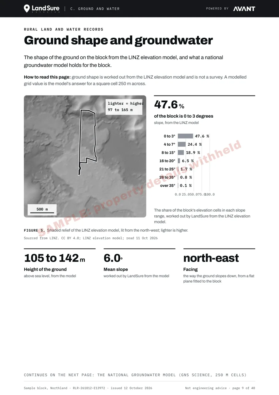
Ground shape and groundwater page: a shaded map of the ground from the LINZ elevation model and the share of the block in each slope class

Ground shape and groundwater - the shape of the ground from the LINZ elevation model.

Surface water and water quality page: a map of rivers, lakes and swamps near the block and the nearest LAWA monitoring sites

Surface water and water quality - mapped rivers, lakes and swamps near the block, and the nearest site in each LAWA water-quality file.
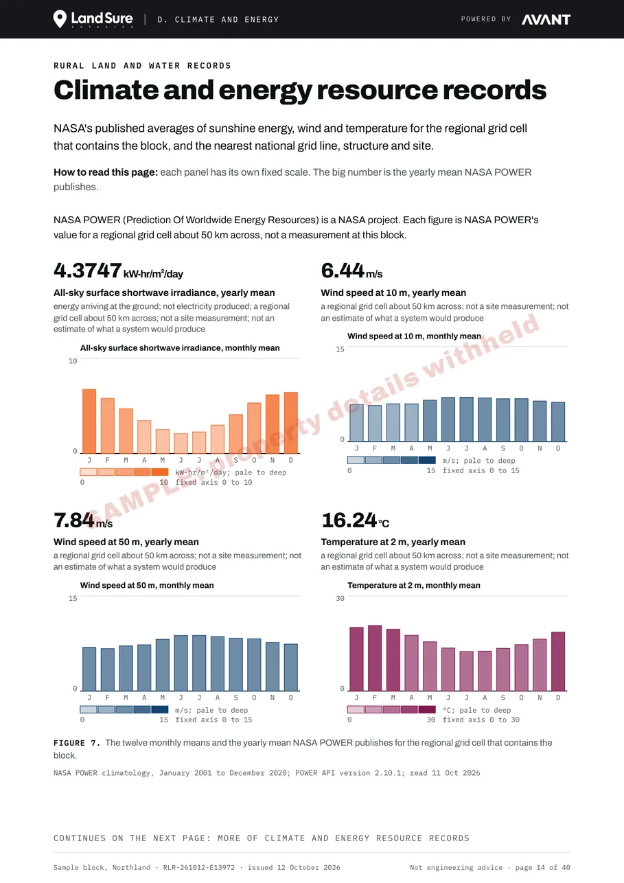
Climate and energy resource records page: monthly charts of sunshine energy, wind speed and temperature for the regional grid cell

Climate and energy resource records - NASA's published averages for the regional grid cell.
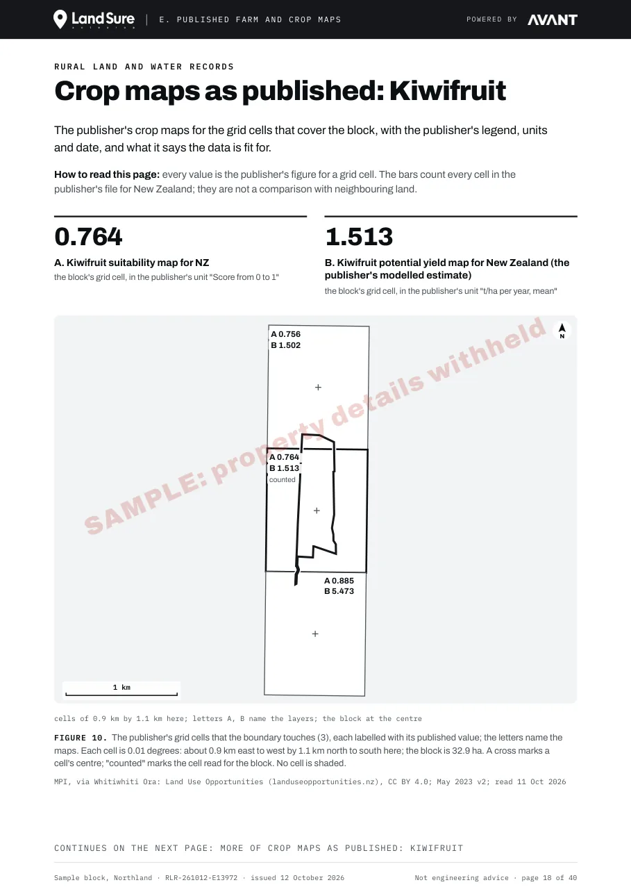
Crop maps as published, kiwifruit page: the publisher's suitability score and potential yield for the grid cells over the block

Crop maps as published: kiwifruit - the publisher's values for the grid cells over the block, with its units and date.
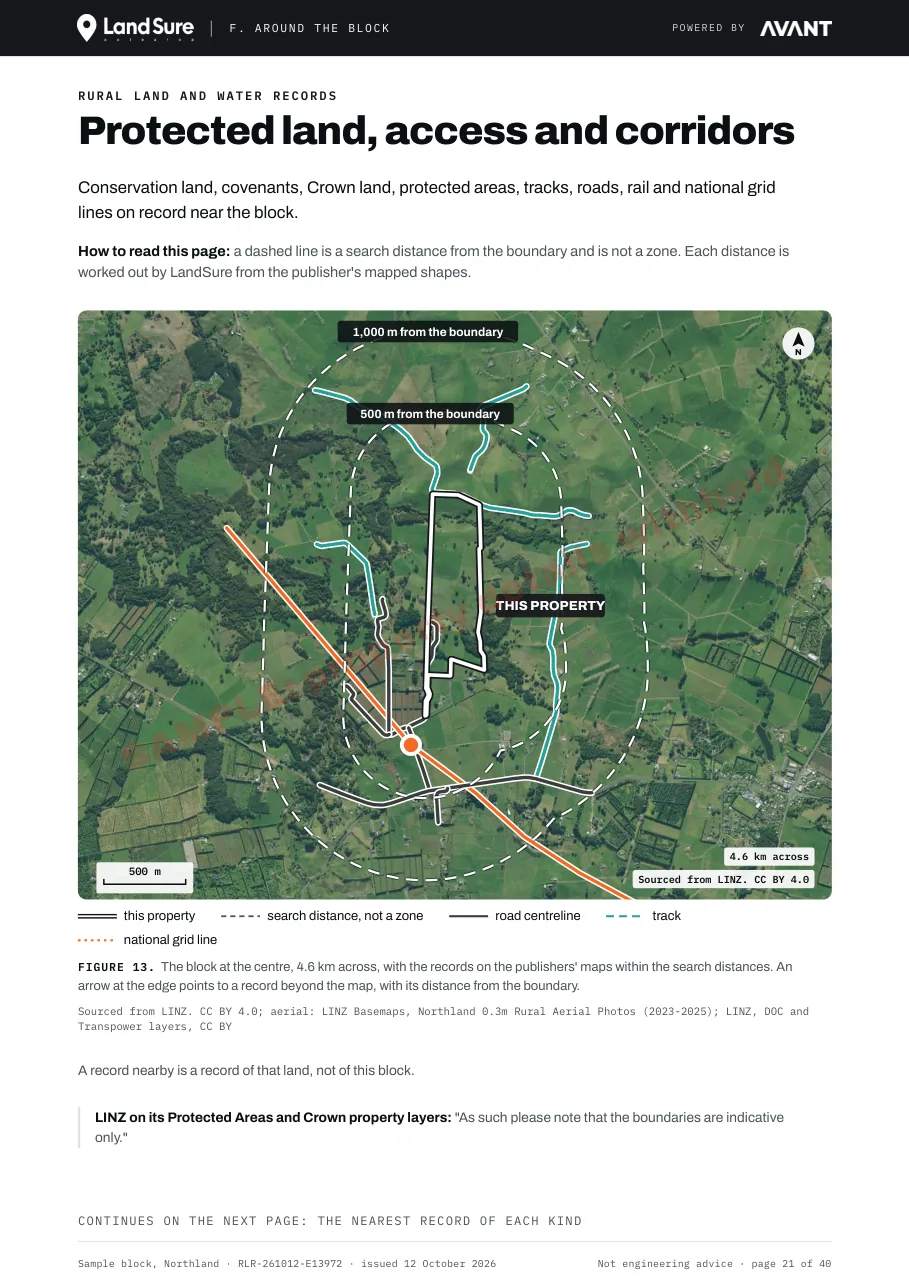
Protected land, access and corridors page: a map of roads, tracks, national grid lines and protected land on record near the block

Protected land, access and corridors - what is on record near the block, with the distance to each.
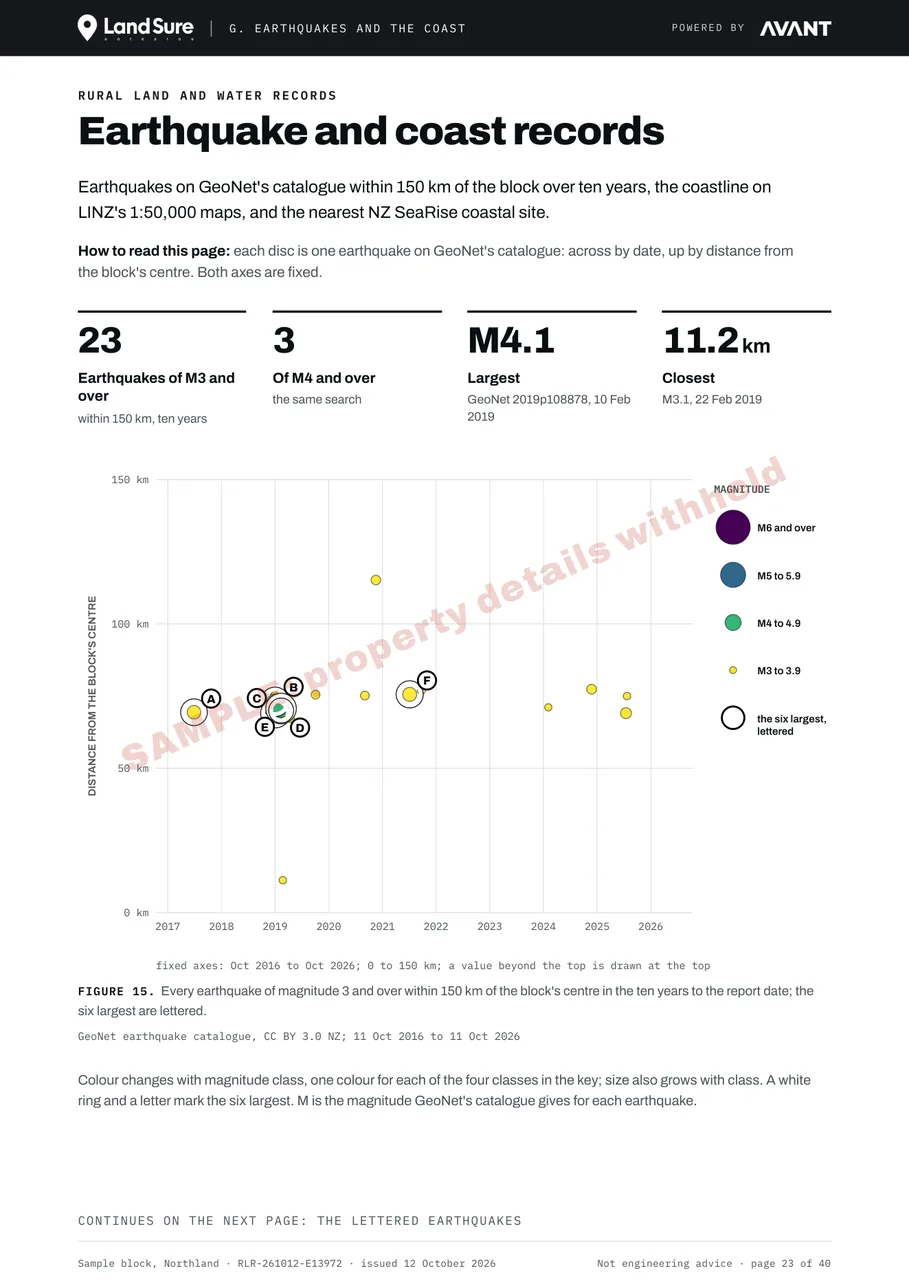
Earthquake and coast records page: earthquakes on GeoNet's catalogue within 150 km over ten years, plotted by date and distance

Earthquake and coast records - earthquakes on GeoNet's catalogue within 150 km over ten years.

Price

Priced by the block's legal area.

Prices are in New Zealand dollars and include GST. The area is the block's legal area from its LINZ record, worked out again when you pay.

Block areaOn its ownWith a Land Movement Report for the same property
Up to 50 ha$199$149
Over 50 ha to 250 ha$249Not with a Land Movement Report
Over 250 ha to 1,000 ha$299Not with a Land Movement Report
Over 1,000 haNot sold onlineNot sold online

Crop pages: $19 each, for kiwifruit, avocado and maize grain. Tick the crops you want when you add the report to your cart.

The lower price applies only when the Land Movement Report in the same payment is for the same LINZ title and parcels. A block over 50 ha cannot be bought in the same cart as a Land Movement Report: speak to the team at support@landsure.ai.

Over 1,000 ha: speak to the team about Rural Land and Water Records for a block over 1,000 ha, at support@landsure.ai.

No discount codes. No owner copies.

How to order

Start with your address.

Enter the address

The property finder looks up the block's LINZ title and parcels.

Add the report and tick your crop pages

From the result, add Rural Land and Water Records to the cart, with the crop pages you tick.

Pay by card

The report is emailed to you as a PDF within 24 hours of payment.

What the report is not.

Please read before you buy. LandSure is not a geotechnical engineer, and this report is not a geotechnical assessment, certification or a professional opinion. It is a set of public records about the block, each with its source and record date. Not engineering advice. The report is issued to you and is for your use only: banks, insurers and councils cannot rely on it. No owner copies. The full terms are on the terms page.

The report covers only the datasets listed in its Appendix B, and names each dataset it left out, with the reason. It is not an inspection: nobody visits the block. It is not a survey, a valuation, a LIM, a hazard assessment or a forecast.

The climate figures are NASA's published averages for the regional grid cell that contains the block. They are not measurements taken on the block.

The pasture, forestry and crop maps are printed as their publishers publish them, with each publisher's legend, units, date and what it says the data is fit for.

Common questions.

A report that sets out public records about one New Zealand rural block: the block and the parcels next to it, land cover from 1996, ground shape and groundwater, surface water and water quality, climate and energy records, published pasture, forestry and crop maps, protected land, access and corridors, and earthquake and coast records. Every figure carries its source and record date.
By the block's legal area from its LINZ record: $199 up to 50 ha, $249 over 50 ha to 250 ha and $299 over 250 ha to 1,000 ha, including GST. Crop pages are $19 each. A block over 1,000 ha is not sold online.
For a block up to 50 ha, yes. The price is $149 when it is bought in the same payment as a Land Movement Report for the same LINZ title and parcels. A block over 50 ha cannot be bought in the same cart as a Land Movement Report.
Extra sections for kiwifruit, avocado or maize grain, at $19 each. Each one prints the publisher's map for the grid cells over the block, with the publisher's legend, units, date and what it says the data is fit for. Tick the crops you want when you add the report to your cart.
No. It is a set of public records about the block, each with its source and record date. It is not an inspection, a survey, a valuation, a LIM, a hazard assessment, a forecast or an engineering or geotechnical assessment.
The report is emailed to you as a PDF within 24 hours of payment.
From public datasets. The sample report reads records published by Toitū Te Whenua LINZ, Manaaki Whenua Landcare Research, LAWA, NASA, MPI, GNS Science, GeoNet, NZ SeaRise, the Department of Conservation, Transpower and Stats NZ. Appendix B of every report lists each source it read, with its licence and period or vintage.
The report is issued to you and is for your use only. Banks, insurers and councils cannot rely on it.

Start with the address.

The property finder looks up the block's title and parcels. Add the report to your cart from the result, with the crop pages you want.